fbpx

Beni to Dolpo Trek via Phoksumdo Lake

0
Price
From£1,999
Price
From£1,999
Booking Form
Enquiry Form
Full Name*
Email Address*
Your Enquiry*
The tour is not available yet.

Proceed Booking

Save To Wish List

Adding item to wishlist requires an account

4316

Why Book With Us?

  • No-hassle best price guarantee
  • Customer care available 24/7
  • Hand-picked Tours & Activities
  • Free Travel Insurance

Got a Question?

Do not hesitage to give us a call. We are an expert team and we are happy to talk to you.

+44 (0)1773 850222

nepal@everestholidays.com

21 days
Availability : Jan 20’ - Dec 23’
London
Kathmandu
Min Age : 16
Max People : 10

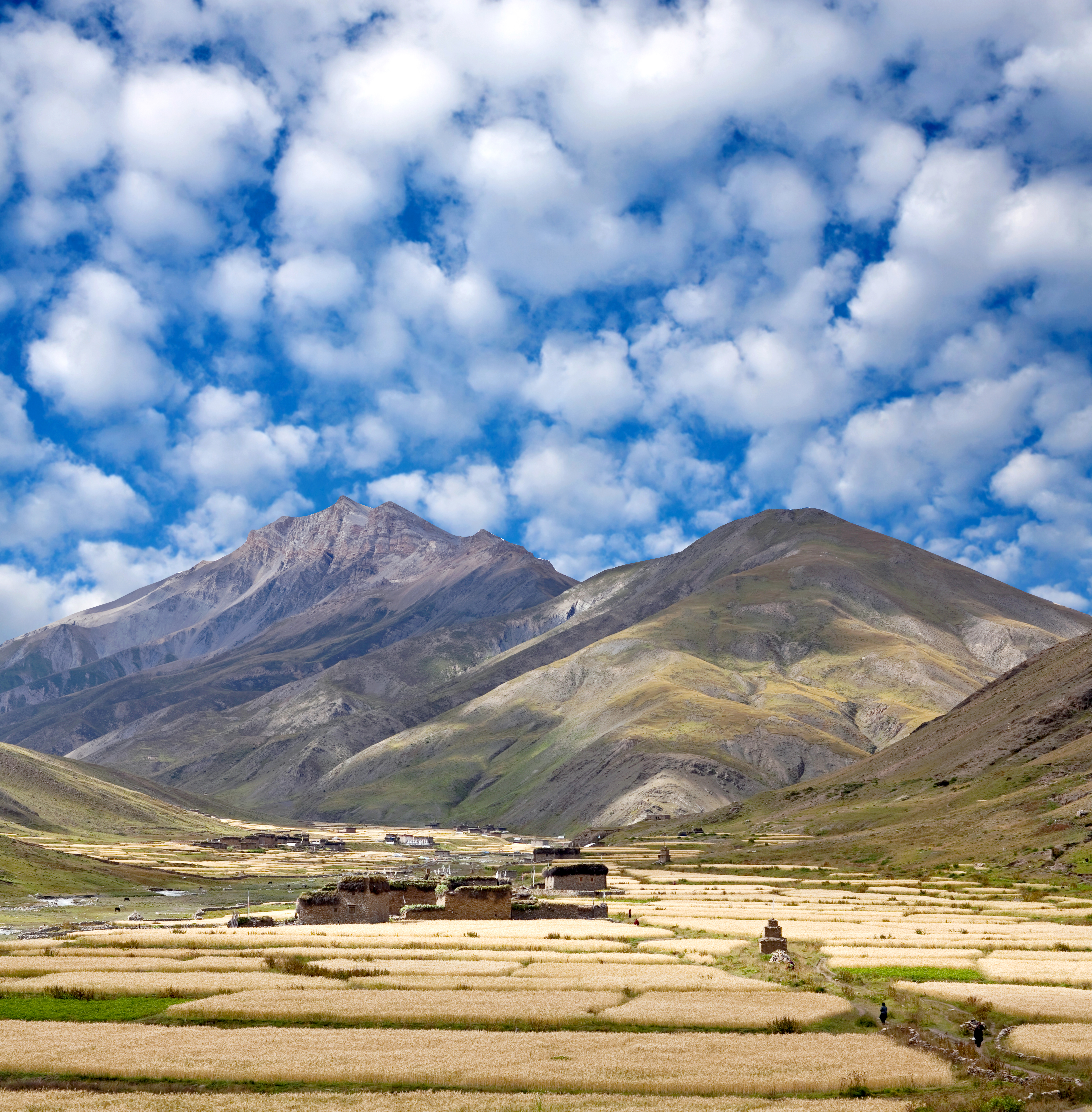
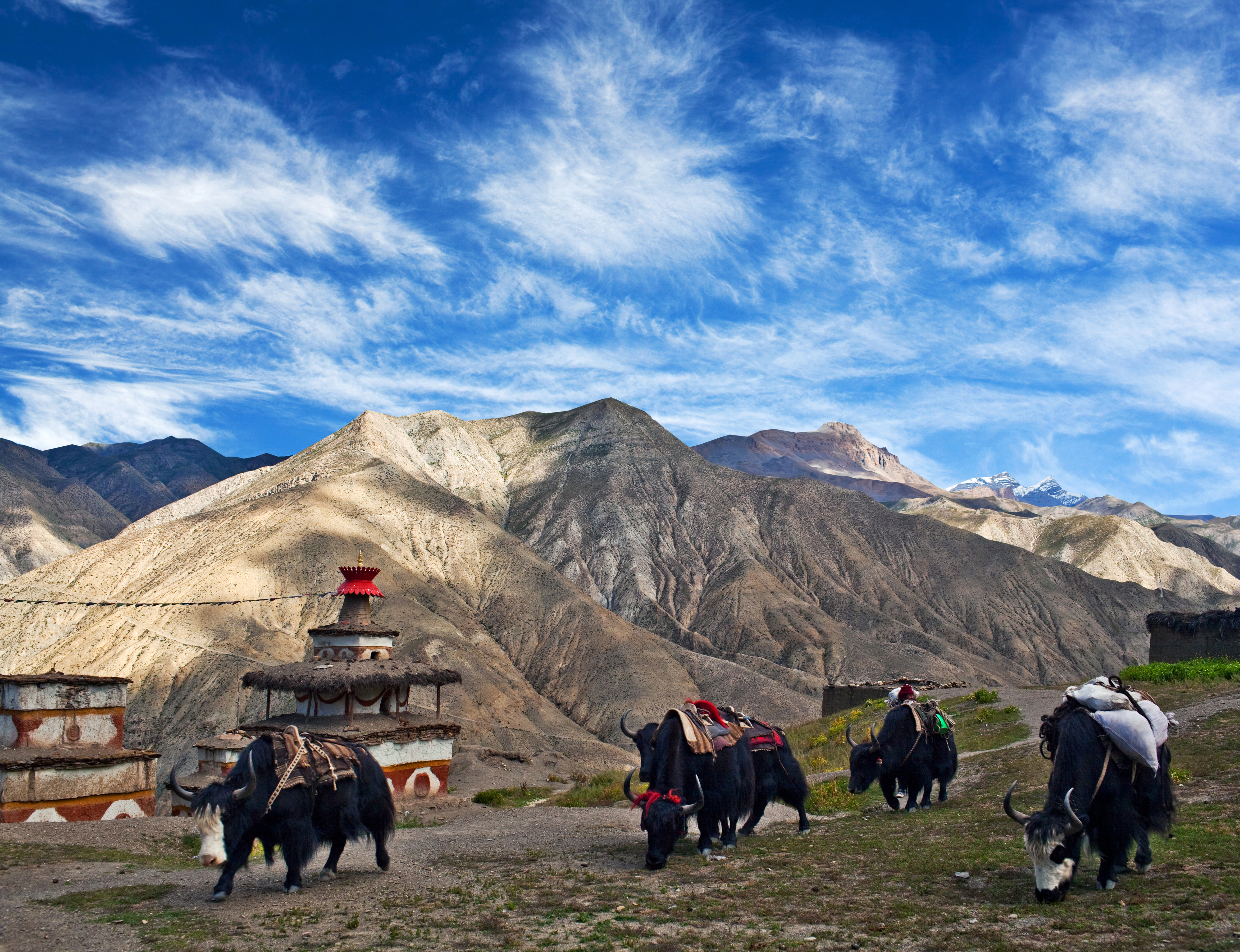
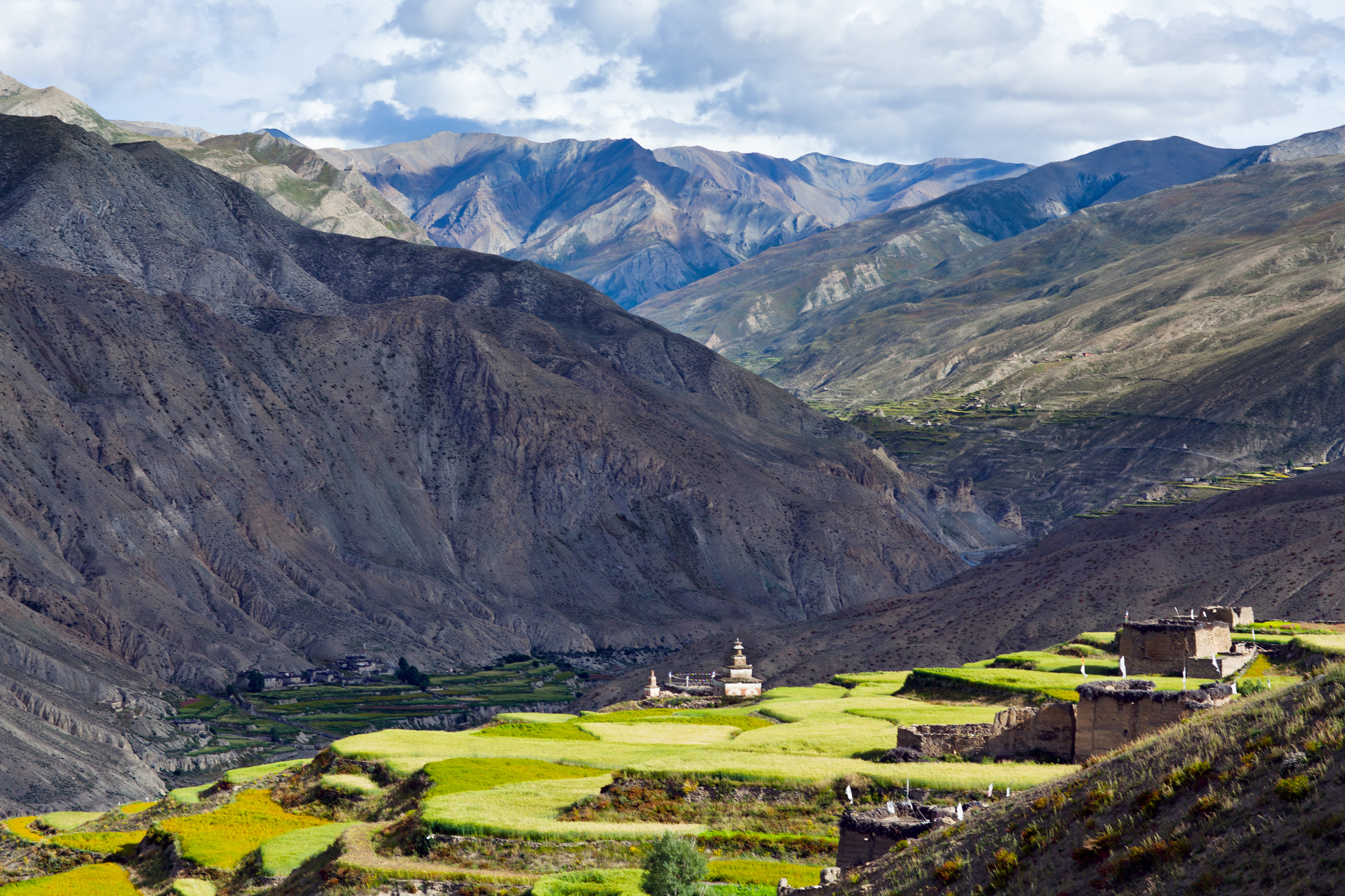
For something more remote, adventurers and Nepal lovers should give our Beni and Dolpo Trek a go. Known among trekking aficionados for its spectacularly remote gompas, colourful yack caravans and dramatic high desert scenery, the Dolpo region is one for the bucket list. This route is described in detail in by George B Schaller in Stones of Silence and by Peter Matthiessen in The Snow Leopard. For anyone who’s read the latter, this trek feels nothing short of a pilgrimage. On this 21 day Beni and Dolpo Trek adventure, we have also included some additional days in Kathmandu and Pokhara so you can not only explore these beautiful areas but prepare yourself for the intense and difficult trek ahead.

Tour Details

This Beni to Dolpo Trek is a long, high and difficult trail over six passes with terrain ranging from rice fields to alpine tundra. This 21 day tour includes 4 nights in Kathmandu, 3 nights in Pokhara, 2 nights in Beni and an intense 12 day trek starting in Beni and ending in Tarakot.

Departure & Return Location

London Heathrow Airport

Departure Time

3 Hours Before Flight Time

Price Includes

  • Air fares
  • 19 Nights Hotel Accomodation
  • Sherpa Guide
  • Entrance Fees
  • All transportation in destination location

Price Excludes

  • Guide Service Fee
  • Driver Service Fee
  • Any Private Expenses
  • Room Service Fees

Complementaries

  • Everest Holidays Travel Bag
  • Sunscreen
  • T-Shirt
  • Entrance Fees
What to Expect

Take the adventure of a lifetime and explore the stunning Dolpo region of Nepal on this Beni to Dolpo Trek. Spend 21 days exploring this beautiful country with 12 days trekking from Beni to Tarakot. Most accommodation is provided for on this trip but you may need to bring a tent and a stove for this trek. Simple lodges, seasonal tents and meals of daal bhaat are available as far of Dhorpatan but you will be required to be self efficient between Dhorpatan and Tarakot. 

  • Return UK Flights
  • Internal Flights and Transfers
  • 4 Nights Total in Kathmandu
  • 3 Nights Total in Pokhara
  • 1 Night in Beni
  • Day Trip to Bhaktapur from Kathmandu
Itinerary

Day 1Fly to Kathmandu

Fly from the UK into Kathamandu where you will be met by our concierge and transferred directly to your 4-star hotel in the centre of Thamel, Kathmandu. Please note flights usually arrive in the late morning although schedules can change.

Day 2Explore Kathmandu

Take a day to enjoy the beautiful atmosphere of Kathmandu. This breathtaking capital has boomed in recent years becoming a busy modern city with a rich medival heart. Explore the streets, restaurants and nightlife after relaxing in your hotel garden with a cup of Nepalise Tea in one hand and a tasty cake in the other. We can also include a day trip to Bhaktapur on your request with a local guide to show you all the best sights.

Day 3Fly to Pokhara

Catch a flight or take an 8 hour drive to Pokhara from Kathmandu

Day 4Explore Pokhara

Spend a night in Pokhara and take the day to explore the area including the beautiful Phewa Lake.

Day 5Transfer to Beni

Catch a transfer to Beni and spend a pre-trek night here. Get lots of rest because your first day of trekking starts tomorrow!

Day 6Trek begins from Beni to Babiyachour (4-5 hours)

The first part of our Dolpo trek starts in Beni heading west along the river from the western end of town, passing a series of five high cascades before starting to climb. Continue though Chutrini where the foot trail joins the new dirt road that heads towards Rakshe and onto Tatopani. There are some incredible hot springs for bathing in Tatopani so if you have time it is certainly worth a dip.

From Tatopani continue on to Simalchaur, though Tara Khet and then finally into Babiyachour named after the local grass ‘babiyo’ which is woven into ropes. In the upper part of the village is a substantial bazaar which boasts the simple Sherchan Guest House and Riverside Restaurant.

Day 7Babiyachour to Dharapani (4-5 hours)

Head out of Babiyachour along the road and about an hour into the walk it’s worth detouring through the traditional stone houses of Sahardara.From the rickety suspension bridge at the end of town, it is just 20 minutes to Raato dhunga, a small bazaar of 1020m. From here the road climbs above the river and into the village of Dar Kharka where you will begin to see the first signs of Buddhist influence in the form of prayer flags.

From there head towards Darbang where you will need to register your passport with the police post. Then it isn’t much longer through the stone houses of Phedi, across the Dayga Khola to Dharapani.

Day 8Dharapani to Lumsum (6-7 hours)

From Dharapani the trail contours up above the village to a crest at 1630m where the mountain views are incredible. Continue to climb along the hill to Sibang and even further over a ridge to get further fantastic views of the steep and jungly Myagdi Valley. Thirty minutes later a pleasant bhatti at Machim offers a good lunch spot.

After lunch, crest a second ridge and descend a stone stairway to cross the Ghatta Khola at the small village of the same name. The main trail stays level as it traverses past a school house to the small settlement of Muna. From here the trail climbs gently alongside the Dhara Khola’s true left bank to a suspension bridge in front of an impressive waterfall. The next hour of walking is a long climb to the Magar village off Lumsum.

Day 9Lumsum to Jaljala La (4-5 hours)

About 30 minutes beyound Lumsum the route crosses the Dhara Khola on a suspension bridge before starting the long climb to Jaljala La. The route towards the pass climbs steeply to scattered houses and a teahouse at Moreni. The peak visible over the ridge to the north is Churen Himal.

Climb through a burned forest to a hender’s goth at 2770m then continue the ridge through of a forest of rhododendrons. It’s a long climb to a notch at 3350m until you reach the large meadow at Jaljala La. The sunset views from the meadow are some of the best in Nepal, stretching across the entire Dhaulagiri massif.

Day 10Jaljala La to Dhorpatan

The trail continues across the plateau, feature great Dhaulagiri views to a second meadow and campsite. From here the trail descends past three wooden bridges, past a stream and some herder’s huts, through a forest of pines to the open valley junction at Gurjakot. Just over 30 minutes from Gurjakot, past a couple of riverside camping spots, the trail suddenly veers right up a side valley to cross the Simudar Kholaa on a suspension bridge.

The first village in the Dhorpatan Valley is Chhyantu which has a couple of basic hotels amidst the apple orchards. Continue past the scattered houses of Bagatar and Baglung to the village of Dhorpatan and the office of the Dhorpatan Hunting Reserve. Just a few hundred metres south of the office is the Dhorpatan Community Lodge and a camping area.

Day 11 Dhorpatan to Takur (7-8 hours)

From Dhorpatan you begin the second phase of the trek and venture north into the largely inhabited wilderness. Continue uphill aiming to the right of a round hill towards a notch where you’ll get your last look of the Dhorpatan Balley. You’ll be able to see Salje village below you. From here the trail descends into the boggy Phagune Valley through rhododendron forests, crossing several streams.

Eventually the trail angles left up a steep eroded gully before emerging atop Phagune Dhuri. From here there are great views of Churen Himal and of Putha Hiunchuili, the ‘butterfly mountain’. From the pass the route descends greatly to a stream and a small campsite. Eventually after a few ups and downs, the trail reaches Dupi Neta before descending into the hidden valley of Takur.

Day 12Takur to Tatopani (6-7 hours)

The route now heads west, past a mill and down the Ghustung Valley, through a forest of fire and oak and past an easily missed holy pond at 2980. After 30 minutes you’ll cross a wooden bridge decorated with ribbon-like spirit traps before climbing steeply to two houses of Ghustung village where you can buy some sugar cane or roasted corn on the cob.

From here, follow the ridge, known as the Selep Danda, for a long distance to Khaim for a convenient tea stop. Then follow the trail down over roots and thick forest, past two villages until you cross the Jatlung Khola to Tatopani.

Day 13Tatopani to Dhule (4 hours)

Today’s walk is relatively short so take your time in the villages enroute or enjoy a late start. The trail crosses the Pelma Khola on a bridge, climbs steeply for 20 minutes and then winds northwest around the hillside. Eventually you pass fields of maize and marijuana that surround Hima village. From here it’s another hour following the valley contours in and out of side valleys to arrive at the larger village of Gulbang.

At Gulbang the trail swings left and climbs out of the Pelma Khola Valley. It’s a long grind up through fields, over a side stream and into a steep rutted gully of rhododendrons. Finally, you crest a pass and make the short descent to Dhule. This settlement is the last until Tarakot so it’s worth getting some extra supplies from here including vegetables and biscuits.

Day 14Dhule to Seng Khola (5-6 hours)

The trail climbs steeply through the moss draped forests about Dhule to the top of a ridge and then continues to climb along the ridge to a chautara. Continue along the ridge above the treeline through scenery reminiscent of the Scottish Highlands to a second chautara where there are outstanding views of the Dhaulagiri Himal. The trail cuts across the bare hillside to the northwest, climbing gradually to what looks like two stone chortens (actually the remains of a kani-style gate) atop Nautale Bhanjyang.

Descend steeply for 30 minutes, then contour above the Seng Khola, a tributary of the Pelma Khola. The trail continues along the west bank of the river, climbing gradually past a small cave, pastures and a goth at the entrance of a side valley. There are some campsites here near the river at 3820m.

Day 15Seng Khola to Purpang (5-6 hours)

About 30 minutes from the goth you branch left, away from the main valley, up the steep grassy slope to a campsite (4030m). From here, head west and cross into a side valley above a small lake. The route climbs gradually towards Panidal La and drops into another basin before heading down to the Saunre Khola. A single goth marks the location of Purpang where there are some campsites on an island in the river.

Day 16Purpang to Sahar Tara (6-7 hours)

This morning’s immediate steep 20-minute climb will bring you to the first mini-pass marked by two rock cairns at 4340m. Traverse into the next valley and follow the stream for around 30 minutes to the foot of the pass. The trail climbs a sandy, rocky ravine to five rock cairns atop Jangla Bhanjyang at 4540m. Here there are epic views over the grey ranges of Dolpo towards Kanjeralwa the peak near Phoksumdo Lake.

From here the trail descends steeply from the pass before making a high traverse through a forested valley from the Jangla Valley to Dunai. The Tarakot trail stays high and keeps to the right as it heads northeast to a ridge at 4056m. Round the ridge and into the valley are fine views of sacred Putha Himal. After passing through a forest draped with Spanish moss, the trail eventually skirts a field beside a good campsite to enter the village of upper Sahar Tara. The village’s Tanti Gompa is worth a visit for its murals.

Day 17Sahar Tara to Tarakot (2 hours)

From the campsite in upper Sahar Tara, descend for 45 minutes through fields past a kani to the main part of Sahar Tara. Descend steeply to the village water supply then contour above fields to Tarakot proper, perched on a spine-like ridge at 2550m. From the ridge the trail drops steeply to a school and a good campsite beside the Chhyada Khola.

Day 18Tarakot to Laini (6-7 hours)

From the school cross the river and climb gently through pink fields of flowering buckwheat. Detour south into a side valley with views of Putha Himal, cross the Yalkot Khola and climb to a trail that hugs the south side of the Thulo Bheri. The trail stays mostly high above the river, climbing to 2670m before descending past cypress trees and white shorten to a high suspension bridge at Laisicap. Just before the bridge you’ll need to register and show your Dolpo permit to the police post.

Cross the bridge to a tented teahouse that offers daal bhaat and a water pipe for washing. After lunch its worth making the short trip to Chhandul Gompa on the far side of the Tarap Chu. Back on the main trail, continue through cedar forest as the valley walls close in. The gorge starts to widen near Laini where you must climb a steep hillside before dropping back down to reach the main trail. You can get tea, noodles and Chinese beer here with some pretty camping spots at the foot of a small waterfalls five minutes on.

Day 19Laini to Nawarpani (5 hours)

The trek today starts straight away with a 50-minute climb on switchbacks to a mini-pass marked with prayer flags at 3540m. The trail then makes a dramatic but enjoyable traverse through a gorge so steep that you can’t even see the river below you. The trail eventually descends to cross the cascades of the Tilba Khola before ascending again on some gravity defying steps. Climb one more ridge and descend to the Chyugur Khola, a small campsite beside a stream.

From here cross the suspension bridge to the river’s left and pass a side stream, the Chaya Khola, to another potential camp spot. Continue to Tazam where a couple of huts offer food before crossing a suspension bridge to the true right bank before arriving at Nawarpani.

Day 20 Nawarpani to Do Tarap (6-7 hours)

As the gorge narrows, cross the true left bank over an ancient-looking bridge and pass a small cave and campsite to climb a thrilling section of the trail chiselled out of the sheer rock face. The trail then recrosses the Tarap Chu on a wooden cantilever bridge at Tal Tole. The route crosses the Tarap Chu on a sort bridge, then climb the east bank through eroded landscape into Serkam.

Descend from Serkam and cross back to the west bank on a crooked wooden bridge high above the Tarap Chu. A kilometre or so further you swing into Sishul Khola before following a rocky trail that traverses beneath cliffs to a bridge at 3920m. Cross to the east bank where a side valley leads up the Lang Chu to the remote village of Lang. From here it is only a 20-minute walk to Do Tarap where there are a couple of lodges and campsites.

Day 21Explore Do Tarap

Tarap is worth exploring, so don’t hurry through this region and take a day to enjoy the area. There is plenty to see to fill a full day here including visiting the monasteries, explore the village or even bagging the peak to the south of the village. The Ribo Bhumpa Gompa above the village is worth seeing. It was rebuilt in 1955 and beside it is a unique ‘chorten in a chorten’ containing the supposed remains of a demon killed by the Guru Rinpoche.

For a leisurely half day excursion, head east up the valley of the Doro Chu for about half an hour to Doro and Shipchok monasteries. The atmospheric Doro Gompha is on the north side of the river and has an unusual side entrance. Across the river is the Bonpo-school Shipchok Gompha, recognisable by the dozen chortens that arc away from the monastery. Look for the wonderfully carved door and finely painted prayer wheel in the atrium.

Day 22Do Tarap to Numa La Base Camp (3-4 hours)

There’s not much walking today but expect to make lots of detours to explore various villages and gompas. Head west out of Do Tarap leaving the village through its impressive kani. After about 20 minutes a side footpath climbs to the century old Mekyem Gompa. Back on the main trail you’ll soon pass the Crystal Mountain School, before continuing uphill to Gakar village and the Dorje Phurba Gompa.

Further on is the Chu Magar and the Tarap Chu (also known as the Thakchio Khola) on a wooden bridge. Here the valley divides, the route to Numa La follows the southern brand passing the white walled Jampa Lhakhang to Tok-khyu village. You can camp at Tok-khyu but it is worth continuing on to Numa La Base Camp which is tucked into a side valley by a stream just before a steep climb, little more than an hour beyond Tok-khyu.

Day 23Numa La Base Camp to Pelung Tang (6-7 hours)

It’s a long pull over the Numa La so start early. From Numa La Base Camp cross the stream on rocks and climb steeply on yak trails up a ridge where there are several mani walls and a chorten at 4580m. Continue up the ridge to a grassy knoll and a tiny stream before dipping into a glacial bowl and making a long climb up a moraine to the Numa La about three hours from base camp. From the pass you can see Shey Shikar and Kanjeralwa to the northwest and the tip of Dhaulagiri to the southeast.

Descend from the pass into a U-shaped valley before swinging sharply left where you can see far across the valley to Baga La. It is worth watching out for blue sheep and snow leopards in this remote valley. Follow the rocky, but spectacularly scenic valley as it drops steeply, crossing a stream and scree slopes. Follow the river down past eroded cliffs before eventually swinging into a side valley towards Phoksumdo Lake. Walk around the ridge of the valley and climb gently into a decent campsite in pastures. This spot is known as Pelung Tang or sometimes known as Danigar.

Day 24Pelung Tang to Dajok Tang (6 hours)

Today will be a tough day if the pass is covered in snow but its not difficult if the route is clear. The trail crosses a stream then switches back up a slope to a meadow known as high camp. The trail then hits the snow line and climbs a ridge to offer views of Norbu Kang, before ascending a moraine into a large bowl marked by chorten. The trail arcs gently around the bowl on a scree slope to several rough cairns atop Baga La, three hours from Pelung Tang,

Descend from the pass, steeply at first, then more gently staying high above the right bank of the stream. At 4390m, the trail turns a corner and enters a huge valley making a final descent on steep switchbacks to Dajok Tang. The stream drops beside the trail in an impressive series of cascades. This is truly a spectacular valley, our favorite of the trek and one of the most scenic in western Nepal with a large moraine at its head and numerous waterfalls shooting off the striped valley walls. Several snowy peaks including Kagmara crows the horizon at the end of the valley. If you have the energy, you can push down the Maduwa Valley to good campsites 15 minutes, 40 minutes or an hour below Dajok Tang.

Day 25Dajok Tang to Phoksumdo Lake (3-4 hours)

Follow a trail down past views of Sonam Kang anda national park building to a collection of five sod-covered herders’ huts. Traverse high above the river through groves of thorny bushes, juniper and blue pine into a valley headed by the distant snowy range of Kagmara Lekh. After an initial descent the trail climbs on an exposed built up cliff side trail. You can see the village of Rilke below to the left and the blue river and trail ascending from Phoksumdo straight ahead. Contour around to a ridge decorated in prayer flags and climb for 10 minutes before you first hear and then see the waterfall across the valley.

The trail descends greatly to the chortens and barley fields of Ringmo village. From here its a 10 minute walk to the shores of the stunning Phoksumdo Lake. There are national park campsites by the park building or better, across the lake outlet.

Day 26Explore Phoksundo Lake

Take the day to relax and explore Phoksundo Lake. This stunning area and water is not something you want to rush, so take your time to enjoy the scenery and rest up your feet for the journey back.

Day 27Phoksundo Lake to Chhepka (4 hours)

Today you will trek back to Chhepka. Head towards Sulighad, following a stream originating from the lake. You will pass through the village of Renje, and fir and larch forests along the Sulighat river before reaching Chhepka at 8,268 feet.

Day 28Chhepka to Juphal (5 hours)

After breakfast, retrace the trail to Juphal through beautiful forests, fields, and villages.

Day 29Fly from Juphal to Nepalgunj and Nepalgunj to Kathmandu

In the early morning, you will fly from Juphal to Nepalgunj and on to Kathmandu, where you will be transferred to your hotel. The afternoon is free to enjoy some sightseeing or rest in your hotel.

Day 30Fly back to UK

Map
Photos